WWW.ILoveLBNY.Com
Long Beach New York
Early Maps
These maps have come from many different sources, some are hundreds of years old.. They show the changing geography of the island. They also show the inlets that have long since closed, marshes filled in to build homes on, old foot bridges and some old structures such as Life Saving Stations. Thanks in particular to the Long Beach Historical Society, Lowell Taubman, Bob Foster, Sam Schwarzman and the the Library of Congress map collection for much of the material, documentation and ideas provided for this page.
This page was last updated on: March 22, 2016
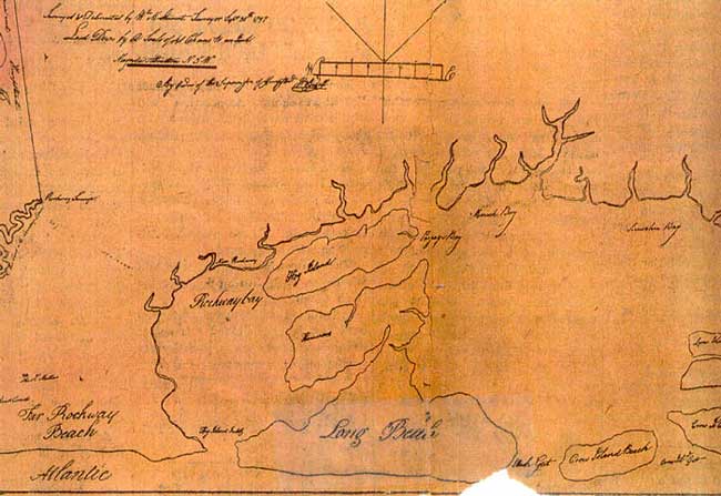
This is the oldest of the bunch, 1797! A very rough map to say the least, but you see that the East Rockaway Inlet (then called Hog Island Inlet) used to open directly into Broad Channel. To the east is another inlet, that would be Luce's Inlet, located approximately where Blackheath Rd is now.
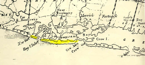
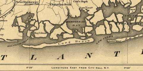
This is an 1843 map. Long Beach is highlighted in yellow.. The western end (left side) really was not part of LB at this time. Notice "Hog I. Inlet". That inlet cut through in the area around New York Ave and Grand Blvd and provided direct access to Broad Channel and the then busy port of Near (East) Rockaway.
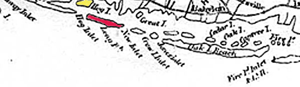
This blurry 1845 map shows some changes to the coastline. Long Beach is in red, what is now Island Park in yellow. New Gut, which separated the western part of the island in the 1843 map above is now gone, possibly shoaled over in a storm. The western end of what would become LB is now attached to the Rockaways. Some changes appear to have happened to the east end around New Inlet also (what is now Jones Inlet) .
Here's a nice, clear 1873 map showing the island. It is missing some detail however, as Luce's Inlet, which should be around the Blackheath Rd area, is not depicted. The Hog I. Inlet and the Rockaway peninsula also appear a bit out of scale.
Things are starting to happen here now !! This is an 1884 Long Island Railroad route map which clearly shows the railroad going to Point Lookout.. Know as the Marine Railroad Company in the area past the Long Beach Station, it later went out of business. It's tracks continually were washed away in storms and they were eventually torn up permanently. The railroad crossed Luce's Inlet in the east end (not shown here) on a low trestle. The black mark on the tracks in Long Beach was the location of the Long Beach Hotel.
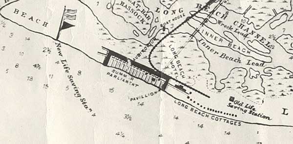
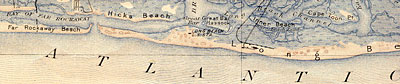
This is a great 1896 map which came from the Town of Hempstead offices originally. It clearly shows a number of important landmarks. The old Life Saving Station, once thought to be in the West End, is shown in it's proper location according to Coast Guard coordinates. That station location was abandoned in 1888. The New Life Saving is shown in the West End, in the area of Lindell Blvd. The Long Beach Hotel is shown along with the summer cottages which were rented by only the very wealthy. The original foot bridge is shown crossing the channel (to the right of the railroad bridge). It is believed automobiles may have crossed this bridge one at a time. The LB Bridge wasn't constructed until 1922.
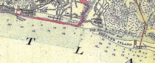
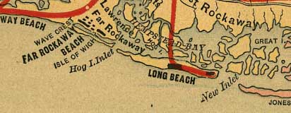
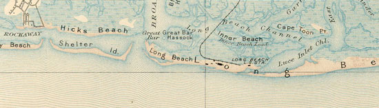
This 1906 map shows the West End. Old Hog Island Inlet has shoaled over and been filled in. This occurred in a storm around the turn of the century. The West End is now connected to the rest of the island. East Rockaway Inlet appears approximately in it's current location, though some continued migration to the west will continue to occur for some years. The flag icon to the right of the Shelter Island wording represents the new US Life Saving Station.
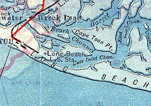
This 1906 map shows where Luce's Inlet formerly cut thru the East End. The area marked Luce's Inlet Channel was once the place where the ocean cut thru. The inlet was probably not navigable however, at least not in the late 1800's. The old Life Saving Station's location is also noted on this map, though it was moved 18 years prior to this map being published.
This is a 1918 Geodesic Survey map showing the entire length of Long Beach island. I had to piece it together from 2 parts.
This is a 1903 map. The East Rockaway Inlet (formerly called Hog I.Inlet) is still in the vicinity of New York Ave in this map. Luce's Inlet Channel is clearly marked in the East End, though the inlet itself was probably completely shoaled over by now. The old Life Saving Station is still located on this map, though it was moved years earlier.
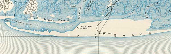
This is a 1923 map. The island now looks very much like it does today. The Life Saving Station (L.S. Sta) seems a bit further north than the Coast Guard coordinates have it placed, and I don't think the rail line extended quite that far south in this year. The Long Beach Bridge is now shown, which opened in 1922. It was not uncommon, even to this day, for map makers to be a number of years behind in relocating, or correcting, landmarks which appeared on previous versions of their maps. Notice here how all the small islands and marshes that were on the bayside in earlier maps have become part of the main island due to the dredging operations.
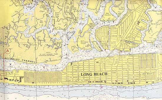
This is a current nautical chart showing how the island and surrounding channels look today.
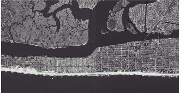
A view from space. A nice satellite image of Long Beach showing the beach clubs in East Atlantic Beach on the left (west) down to about Franklin Blvd on the right (east). Island Park and Harbour Island are visible in the upper right. Photo courtesy of Justin Toumey (though I don't think he snapped this one himself !!!)


WWW.ILoveLBNY.Com
LONG BEACH, NEW YORK

Photo Directories
.
Early Long Beach Maps
WWW.ILoveLBNY.Com
Long Beach New York
Early Maps